
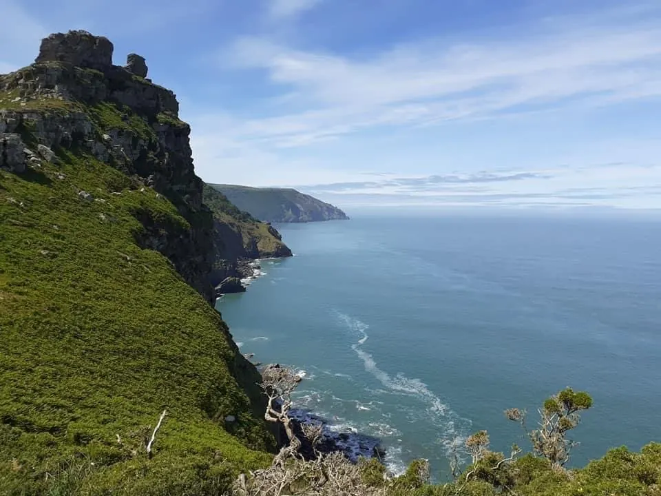
Walk west out of Lynton along the cliffs and the town soon gives way to something older. The Valley of Rocks is a U-shaped dry valley that runs parallel to the sea, about half a mile west of the town. There is no river in it. There is turf, bracken, scattered boulders, bare ridges of stone and, often, a goat standing somewhere improbable.
A valley without a river
Nobody is quite sure how it happened. The Exmoor National Park Authority gives two explanations. In the first, the valley is a dry river bed where the River Lyn once flowed, before it broke through by its current, shorter route to Lynmouth and left the valley high and dry. In the second, advancing ice sheets in the last Ice Age, about 20,000 years ago, blocked the river and forced it westward to cut a new valley; when the ice retreated, the river returned to its old channel and the Valley of Rocks was left without one. The South West Coast Path Association adds a third idea held by some geologists: that the sea wore the coastline back to a bend in the river, creating a cliff waterfall that kept eating inland. Visit Exmoor notes that the U shape was not carved by a glacier; the valley silted up over time.
The stone itself is among the oldest on Exmoor, up to 400 million years old, laid down when the land lay under a shallow sea. The National Park Authority says you can still find ripple marks and fossils in it. People came much later, though not recently: archaeological evidence shows people living and farming in the valley around 3,500 years ago.
Castle Rock, Rugged Jack and the Devil’s Cheese Ring
The landmarks have names, and most of them have stories. Castle Rock is the towering mass that comes into view as you enter the valley from North Walk. Look for the White Lady, a shape that appears in the cracks between its boulders; there is a sign pointing her out. Across the valley stands the pile of rocks known as the Devil’s Cheese Ring. On the approach from Lynton is the craggy tor of Rugged Jack, where, local legend says, the Devil turned a party of merrymaking Druids to stone for dancing on a Sunday. A small pass runs between Rugged Jack and Chimney Rock.
The Cheese Ring has its part in R. D. Blackmore’s novel. In Lorna Doone it is the home of Mother Meldrum, the white witch, and Blackmore describes the valley as “a green, rough-sided hollow, bending at the middle, touched with stone at either crest”. The café in the valley is named after her.
The poets knew the valley too. The Exmoor Historic Environment Record describes Samuel Taylor Coleridge and William Wordsworth taking one of their favourite walks along the coast to the Valley of Rocks, and says the valley inspired an unfinished prose tale, The Wanderings of Cain. Wordsworth later recalled setting out with Coleridge and his sister Dorothy “with a view to visit Linton and the Valley of Stones”, and wrote that “in the course of this walk was planned the poem of the Ancient Mariner.” Robert Southey, writing in 1799, called the bare northern ridge “the very bones and skeleton of the earth”. Near the cricket ground, a poets’ shelter has mosaics showing how the landscape worked on Shelley, Coleridge and Wordsworth.
The goats
Goats have grazed here for a very long time. The Domesday Book recorded 75 goats in the Manor of Lyntonia. A feral herd roamed the valley until the mid-nineteenth century, when farmers culled them for butting sheep off the cliffs. A replacement herd of white goats was brought in at the start of the twentieth century, but had died out by the mid-1960s. The present herd came from the Cheviot Hills in Northumberland in 1976. They are descended from domesticated stock but live wild, and the valley is judged able to support around 25 of them, so there are periodic culls. Visit Exmoor describes them roaming freely, and often hair-raisingly, along the jagged cliff edges. They also wander into Lynton after garden plants, which is why there is a wooden gate across North Walk. Close it behind you.
Walking there from Lynton
The South West Coast Path Association’s circular walk, Lynton and the Valley of Rocks, is 2.9 miles (4.7 km) and graded easy. It starts at the Lynton station of the cliff railway. From there, go out to the main street, turn left down to St Mary the Virgin church, then turn left down North Walk Hill. At the bottom a bridge crosses the cliff railway, with views over Lynmouth to the lighthouse on Foreland Point, and the Coast Path follows North Walk west along the cliffs. The path is surfaced with tarmac and relatively level. After about half a mile Rugged Jack appears on the left; then Castle Rock comes into view and the tarmac ends as you enter the valley. You can return along the road, past the car parks, toilets and picnic area, or take the path signed for North Walk back through the pass.
For something shorter, the National Park’s Valley of Rocks stroll starts at the lower car park: 0.4 miles (600 metres) there and back to the foot of Castle Rock, or a 1-mile loop. The café at the start is seasonal.
If you are coming up from Lynmouth, the Lynton & Lynmouth Cliff Railway does the climb for you. It opened in 1890, is Grade II listed and is worked entirely by water drawn from the West Lyn River. Its operator describes it as the highest and steepest totally water-powered railway in the world, with the top station some 500 feet above the lower one. It runs seasonally, and the days change through the year, so check the fares and opening page before you plan around it.
These are high cliffs. The National Park Authority warns that the coast path section of its stroll is narrow, with unprotected drops and few passing places, and the path over the ridge back towards Hollerday Hill rises at up to 1 in 4 for about 100 metres. Keep to the path, keep children and dogs close near the edge, and give the goats room: they are wild, and they are better on those ledges than you are. In wind or low cloud, the road through the valley is the shorter way back to Lynton.
Where to stay
- Pip’s Corner, Lynton – sleeps 6. Its own listing notes wild goats in the nearby Valley of the Rocks.
- Penthouse Lynmouth Bay, Lynton – sleeps 6.
- The Cottage at Woodlands, Lynton – sleeps 2, with a private sunny terrace.
- Lorna Doone Cottage, Lynmouth – sleeps 4, with a wood-burner in the living room.
Sources
- Exmoor National Park Authority, “The Valley of Rocks”, https://www.exmoor-nationalpark.gov.uk/exmoor-for-everyone/things-to-do/the-valley-of-rocks — two formation theories (dry River Lyn bed; Ice Age about 20,000 years ago), rocks up to 400 million years old formed under a shallow sea, ripple marks and fossils, Southey’s 1799 description (“the very bones and skeleton of the earth”).
- Exmoor National Park Authority, “Exmoor Strolls No. 10: Valley of Rocks” (route guide PDF), https://www.exmoor-nationalpark.gov.uk/__data/assets/pdf_file/0024/4848/10-Valley-of-Rocks.pdf — lower car park start, 0.4 mile (600 m) to Castle Rock and back, 1-mile loop, narrow coast path with unprotected drops, 1:4 section of about 100 m over the ridge towards Hollerday Hill, seasonal Mother Meldrum café, people living and farming in the valley around 3,500 years ago, goats mentioned in Domesday and living wild from domesticated stock, wandering into town for garden plants, café named after Mother Meldrum, the white witch of Lorna Doone.
- South West Coast Path Association, “Lynton and the Valley of Rocks”, https://www.southwestcoastpath.org.uk/walksdb/247/ — 2.9 miles (4.7 km), easy grade, start at Lynton cliff railway station, route via main street, St Mary the Virgin church, North Walk Hill, bridge over the cliff railway, view to Foreland Point lighthouse, tarmac and relatively level path, gate to keep goats out of town, goat history (75 in Domesday Manor of Lyntonia, mid-19th-century cull, white herd, died out mid-1960s, Cheviot herd from Northumberland 1976, around 25, periodic culls), Rugged Jack after about half a mile and Druids legend, Castle Rock, third formation theory (cliff waterfall), White Lady, Devil’s Cheese Ring and Mother Meldrum, Blackmore quotation, poets’ shelter mosaics (Shelley, Coleridge, Wordsworth), Chimney Rock, return routes.
- Visit Exmoor, “Valley of Rocks”, https://www.visit-exmoor.co.uk/things-to-do-around-exmoor/natural-attractions/valley-of-rocks — U-shaped dry valley parallel to the sea, about ½ mile west of Lynton, goats on jagged cliff edges, U shape from silting not a glacier, toilets and picnic area at the Lynton end.
- Exmoor Historic Environment Record (Exmoor National Park), “Exmoor and the Romantic Poets”, https://www.exmoorher.co.uk/theme/TEM31 — Coleridge and Wordsworth’s walk to the Valley of Rocks, The Wanderings of Cain, Wordsworth’s recollection of visiting “Linton and the Valley of Stones” and planning the Ancient Mariner.
- Lynton & Lynmouth Cliff Railway, home page and “How it works”, https://www.cliffrailwaylynton.co.uk/ and https://www.cliffrailwaylynton.co.uk/about/how-it-works/ — opened 1890, Grade II listed, highest and steepest totally water-powered railway, water from the West Lyn River, top 500 ft above the lower station.
- Lynton & Lynmouth Cliff Railway, “Fares and opening”, https://www.cliffrailwaylynton.co.uk/visit-us/fares-and-opening/ — seasonal operation with dates that vary through the year.